Zion National Park – Hiking Hiking Hiking

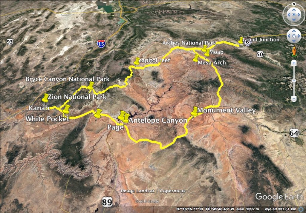
Thanks to our failure in the lottery for the Wave, we had plenty of time in Zion National Park.  Being different from other national parks in our Grand Circle trip, Zion has more plants, and seems more family friendly.  Zion is only 40 minutes away from Kanab.  Private cars are asked to park in the big parking lot close to the visitor center.  Shutter buses are running every 10-20 minutes, depending on the season and time.

Zion National Park checkerboard mesa

There are numerous hiking trails in Zion.  The two most famous and difficult ones are called The Narrows and Angel’s Landing.  We did both!
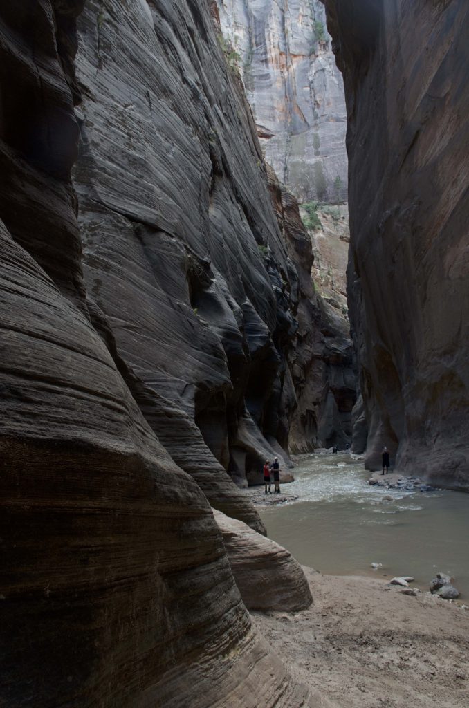
The Narrows
The trail is actually a section of the Virgin river running in the canyon.  It is thus very important to check the weather and the flood potential.  There are special preparations needed to be done as well.  Keep in mind that the water may be cold!  Even in early September when the sun is out and people are wearing shorts, the water is cold.  This is because the river runs in the narrow canyon, and does not get much sunshine.  Also, prepare “special”  shoes because they will get wet for sure.  The other thing may be useful is a stick, as walking in the river is difficult – you cannot see how deep the water is or what you are going to step on.  We didn’t have sticks, so we were quite slow.

Two ways to hike The Narrows.  One can either hike top-down or bottom-up.  Top-down is an overnight hike, and requires permits. Bottom-up is easier, and requires no permits.  Therefore most people, including us, choose the bottom-up hike.  We took the shutter to Temple of Sinawava.  After hiking the 1 mile riverside trail, we reached the starting point of The Narrows.  I could see that people were excited to hike this special and unique trail!  The first step into the water was really cold.  After a while, I kinda got used to it.  Walking in the river was more difficult than I thought, but it’s a lot of fun!  My mom and I sometimes had to hold hand to stabilize each other.  We reached the starting point of Wall Street, and then decided to return.  In total, we hiked about 5 hours.
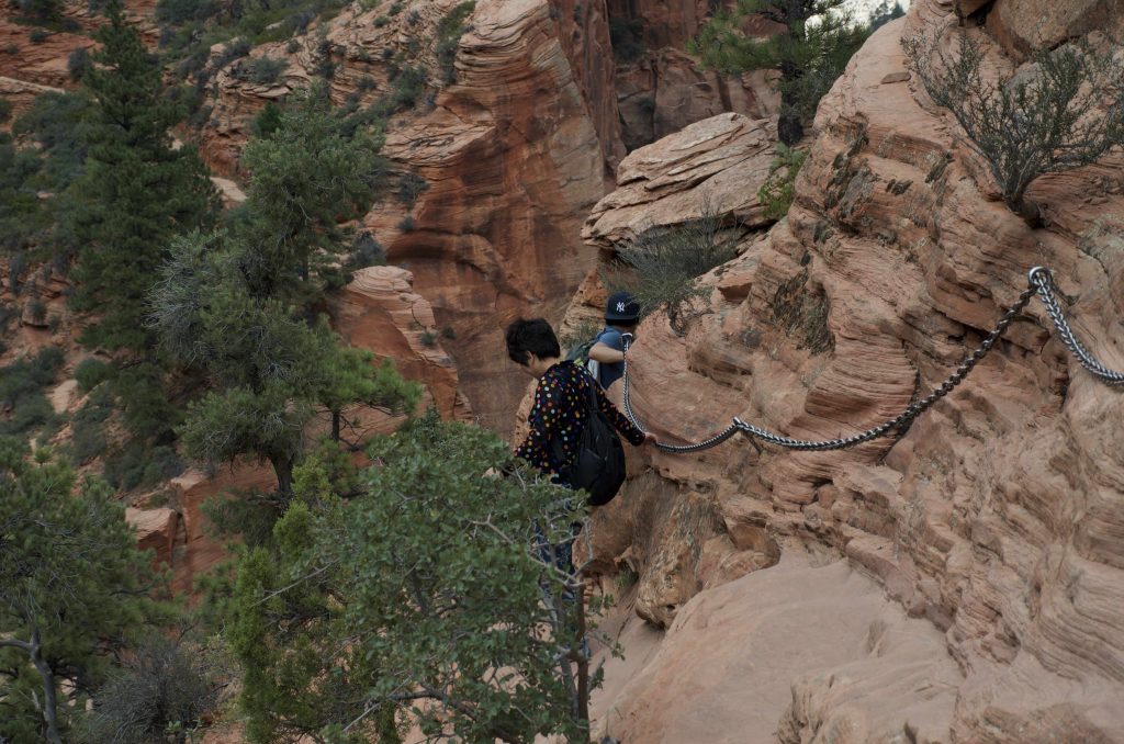
Zion National Park
Zion National Park the narrows

Angel’s landing
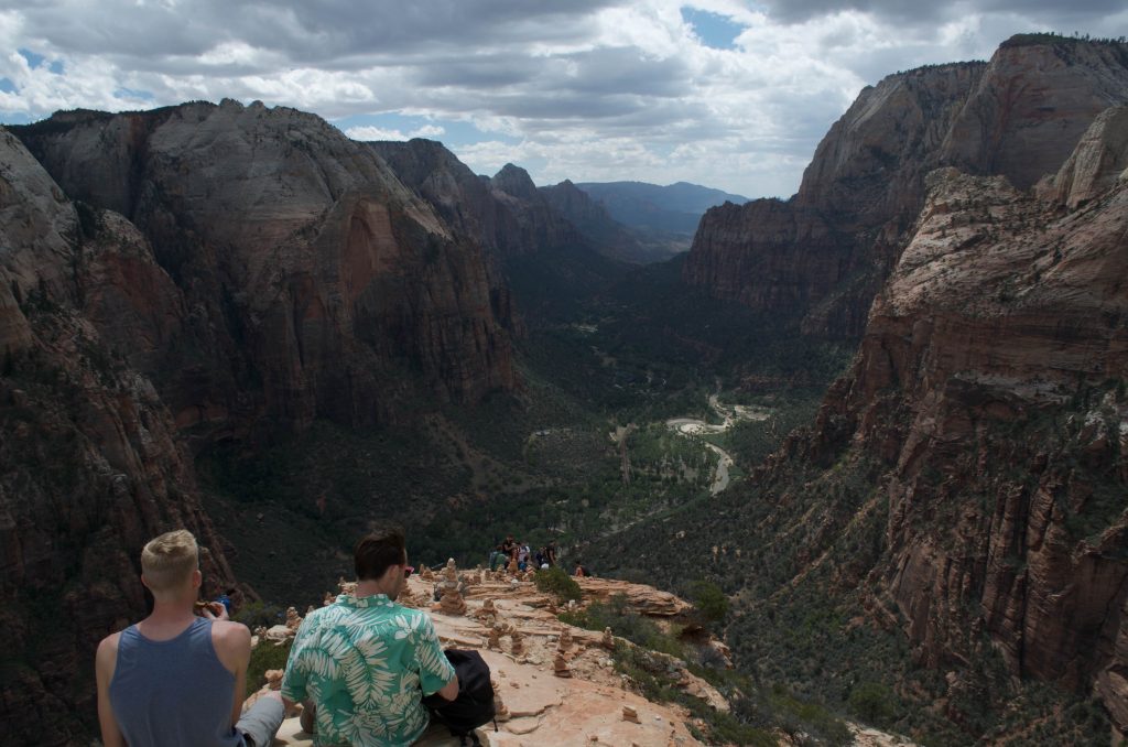
This is also a unique trail.  The first half of the trail is paved road.  However, the rest is rocks.  There is a thick chain along the trail, so I don’t find it very dangerous.  In fact, I liked it a lot! :). It reminded me the Yellow Mountain in China!  The trail to one of the highest peaks, Tiandu Peak, is a bit similar.  But it’s a lot more steeper on Tiandu Peak!  (I recently revisited Yellow Mountain, and I will write about it. D had already finished his blog about Yellow Mountain.)  The end of Angel’s landing is the top of the mountain.  Many people were sitting there and enjoying the view.  We didn’t stay long, because we had to drive to Bryce Canyon National Park.

Zion National Park
Zion National Park angel landing chain
Zion National Park
Zion National Park angel landing top

I am sure everybody can find some trails that they enjoy in Zion.  I just feel lucky that we could do the two most unique ones!

One more thing about Zion.  There are a lot of restaurant in Springdale.  We tried one Thai restaurant (Thai Sapa), and the food we had there were surprisingly good!

Monument Valley Navajo Tribal Park – sunrise again?

Monument Valley kinda represents The West, as one can see in some movies about Westerns.  It’s the second major stop, following Arches National Park, in our Grand Circle trip.  Driving from Moab to Monument Valley Navajo Tribal Park takes almost 3 hours.  We were hoping to catch the sunset!  So we kept driving, except for a brief break at Mexican Hat.  The weather was actually not promising.  When we got closer to Monument Valley, we were caught in a storm.  My plan of taking a photo of the straight road going towards those iconic sandstone buttes vanished!

When we arrived at the park, the storm has just passed.  After paying the entrance fee ($20), we went ahead to the hotel – The View Hotel – the only hotel inside of the park.  It’s the most expensive hotel we booked in our entire Grand Circle trip, almost $300 (on top of that, we also paid for the breakfast).  Obviously we had high expectations for it.  The style and color of the building match the surrounding very well.  The hotel is almost like part of the park itself.  The terrace is big, providing good views of the valley.  The room is a typical American standard room.  Not a bad size!  The best part – also the most expensive part – is the private balcony!  We could see the whole valley without going out of the room.  Plus, the balcony faces east, which means sunrise can be seen directly from the room as well!  To be honest, I have never been to a balcony that gives such extraordinary view…  The whole valley was there for me to enjoy, in peace.

Sunset was not possible that day.  But the air felt fresh after the storm.  The temperature was very pleasant!  And the valley looked more peaceful.  I couldn’t help to admire those sandstone buttes, which have been standing there for who knows how many centuries.  We didn’t go to the restaurant for dinner.  Somehow we had a crave for instant noodles 🙂

The sky got darker and darker.  We saw a few cars (lights) were driving in the valley.  Were they local Navajo residents?

The second day, I got up early, and went out to the terrace with my camera (+ tripod).  Yes, sunrise again!  Why not?  No need to drive, no need to hike – it’s probably the easiest sunrise (although people often miss the easiest things).  I took many photos, with different settings.  D and my mom didn’t come out.  They saw sunrise on the balcony – a slightly different angle but equally good.  I had to come out because I wanted a bigger view.  It was a bit cloudy!  But not too bad.  The sun rose behind the center butte.

As mentioned earlier, we bought tickets for the breakfast buffet.  The restaurant has big windows so people can enjoy the view of the valley while enjoying their meals.  However the buffet was normal… not many choices.  I kinda missed the breakfast in Best Western.

After the breakfast, we checked out.  But we didn’t leave!  Instead, we went for hiking.  The only hiking trail in the park is called Wildcat, starting from the hotel.  We spent some time looking for the start point of the trail.  It was not as straightforward as we thought.  Anyways, we found it!  We hiked around one of the sandstone buttes.  The closeup view was a totally different experience!  We had to look up the sandstone butte –  it’s so tall.  Also, we got to get close to the local plants and animals.  The temperature raised quickly as the day proceeded towards noon.  We took many water breaks, and enjoyed the company of a dog (may belong to somebody).

Then we went for the 17 miles scenic drive.  The road condition was much better than we thought.  A 4WD was not necessary.  Since hiking is not allowed without a guide, we basically stayed on the main road, and finished the loop quickly.  I am surprised that I don’t have much to say about the drive… but it’s definitely worthing going!

With all the good memories of Monument Valley, we hit the road towards Page, Arizona.  

X

Sunrise at Mesa Arch in Canyonlands National Park

It’s the second day of our Grand Circle trip, and we planned to see sunrise at Mesa Arch.  Since my mom got a little injury in Arches National Park the previous day, she didn’t join us for the sunrise.  We also thought it’s better for her to rest more so that she would have energy later.  However, it’s really a pity that she missed the best sunrise in the whole trip!

The driving from Moab to Mesa Arch, which is in Canyonlands National Park, was about 45min.  In order to get a good spot for photography, we got up and hit the road very early (4:30am, 2h before the sunrise).  I kinda remember that I was in the driver’s seat, so that D (my husband) could rest.  After all, I am the one who is crazy about sunrise and sunset!  It was still dark when we arrived at the trailhead parking area.  But don’t worry – we had headlights!  So prepared!  The trail was said to be a 0.7 mile loop, so it should be only ~600m to the Mesa Arch.  However, it took us a while to figure out which way to go, because the trail was not that obvious (remember? It’s dark).

We were among the earliest at Mesa Arch!  I tested a few spots with my camera, and finally settled down.  More and more people came.  My spot was probably good, because several tripods were set up besides me.  We were all quietly waiting for the moment.  On the other hand, D was walking around – climbing up and down.

Canyonlands National Park
Waiting to see sunrise

The east started to show some red.  After a while, the first sunshine came out and lighted up the quiet canyonlands.

Canyonlands National Park
Sunrise at Mesa Arch

We were still waiting.  The moment has not come yet!  People’s eyes were all on Mesa Arch.  Slowly, the bottom part of the arch started to turn to a burning orange-red color!  This magic didn’t last long, as the sun was rising.

Canyonlands National Park
Burning Mesa Arch

After the color faded on Mesa Arch, it’s officially post-sunrise.  The sky was already bright.  We realized that Mesa Arch was right on the cliff edge.  Overlooking the vast canyonlands was also an unforgettable experience to us. Unfortunately, not a good time for photos (against the sun).

Canyonlands National Park
Overlooking the canyonlands

On the way back to hotel, we were quite excited.  Plus, the breakfast in the hotel (Best Western Plus Canyonlands) was great!

X

First target in Grand Circle – Arches National Park

We arrived a t Moab in the early afternoon.  After checking into the hotel (Best Western Plus Canyonlands Inn), we did grocery shopping (City Market) to prepare for our Grand Circle trip: water and snacks.  Our original plan was to leave for Arches around five o’clock.  But we arrived one hour early, and didn’t want to wait in the hotel (which turned out to be a bad decision).

Arches National Park is only 8 minutes from Moab.  We got a national park annual pass at the gate, for $80.  After quickly going through the visitor center (we failed to get the ranger-guided tour to the Fiery Furnace), we headed towards the trailhead of Delicate Arch.  The goal was to see the sunset and the moonrise (full moon) there.

After about half an hour, we found the trailhead (Wolfe Ranch parking area).  The trail is 1.5 mile one-way, and climbs up ~150m. The thing was it’s really really hot!  The temperature in the forecast was 39 or 40 degree C, and it should be much higher on the rock.  After hiking about 20 minutes, my mom suddenly fell towards the front when she was drinking, and I couldn’t catch her!  She hit the ground (rock), but was still trying to hold the water bottle.  Fortunately it’s a relatively flat area, otherwise I cannot imagine!  Her nose was scratched by the sunglasses.  Her knees were bleeding a little.  My husband (boyfriend at the time) and I helped her to move to the shade, and washed her wound.  We asked her to drink water and just rest.  She probably passed out for a second because of the heat!  Plus, we didn’t take any break during the 20min hike… Not to say that we had an early and long flight, and some driving!  We really should have rested more in the hotel.

Arches National Park
Delicate Arch and people waiting to see sunset

We gave up Delicate Arch, but could see it from the Lower Delicate Arch Viewpoint.  Then, we went to the Windows Section, because arches there require little hiking.  When we were leaving Arches, we saw the moonrise.

Arches National Park
Arches National Park Spectacles Arch

The second day, we came back to Arches again, after seeing the sunrise at Mesa Arch in Canyonlands National Park (I have to write a separate post for Mesa Arch because it’s too good) 🙂

My mom seemed recovered from the first day, so we decided to try a little bit hiking again!  This time Devils Garden.  It was also a sunny day.  The driving from the visitor center to Devils Garden was half an hour.  The trailhead is a big parking lot, and has restrooms.  The trail is quite easy.  And more importantly, we were more prepared, both physically and mentally!  The total distance covering all the trails is 7.2 miles, but we didn’t set a goal.  We hiked at a slow pace, and took many water breaks (even when we didn’t feel the need to take a break).

Arches National Park
Landscape Arch, Arches National Park

So it was a leisurely hike.  We saw Landscape Arch!  This arch is very different from the others.  So long, and so thin.  Interestingly, there were many small rocks below it – looked like debris of collapses.  It’s said that Landscape Arch may break/disappear one day?

We didn’t have energy to hike to the Double O Arch, so just took the same way back.  We were very pleased with the 2h hiking 🙂

After a quick bite in a cafe in Moab, we started driving towards Monument Valley


X

Horseshoe Bend makes you want a wide-angle lens

After the Antelope Canyon tour, we went to see the Horseshoe Bend, which was only a short drive from Page, Arizona.  To get to the rim of canyon to see the bending Colorado River, one must hike the ~0.7 mile trail.  Yes it’s just a short trail, but imagine hiking in a hot and dry environment (> 37 degree C), under the early afternoon sun, and on a sandy surface.  We had to take a water break every 150-200 meters.

Horseshoe bend Page Arizona
Horseshoe bend trail

When we reached the rim of canyon, the extraordinary view made us forget about everything else.  The jade-color Colorado River plus the reddish sandstone – perfect!  And the horseshoe-like turn (wide sweep) made by the river is simply amazing!  This place reminds me the Grand Canyon, but isn’t the color of Colorado River red there?  I would have to check my Grand Canyon photos later.

Horseshoe Bend
Colorado River makes a wide sweep around a sandstone
Horseshoe Bend
The beautiful Colorado River

Photos!  I tried many spots to take photos.  Luckily I was not afraid of height!  The lens I had was 18-140mm, so the frame could barely cover the whole ring of Colorado River.  However, it would be much better to include more of the canyon and the blue sky as well.   I needed a wide-angle lens, didn’t I?

I also wish I could see sunrise here.  That should make a great photo!  But I figured it might be too tough for my husband and my mom if I requested sunrise/sunset stuffs everyday… At a middle point of our Grand Circle trip, we were already very tired.


X


Bryce Canyon National Park – the unforgettable starry night

Bryce Canyon National Park was the last stop in our Grand Circle trip.  Since we spent three days around Kanab (for The Wave lottery), and we needed to drive 6 hours to Grand Junction, we didn’t have much time in Bryce – only one night and one morning!

When we arrived at Bryce, it’s almost the sunset time.  I think we went to the sunrise point for the sunset (counterintuitive).  Unfortunately, it was a bit cloudy that day.  Thinking about our whole Grand Circle trip, we seemed to have better luck for sunrise than sunset.  Anyways, we were still impressed by the hoodoos!

Shortly after the sunset, we went to our hotel Best Western Plus Ruby’s Inn (right outside of the park).  The hotel is like a big resort.  The lobby is Mountain style, and has a lot to offer.  Still, the best part is its easy access to the park!

For the first time in our Grand Circle trip, we went out to do star gazing.  And truly, Bryce is the best place that I have been for stars.  The clouds were all gone, and the starry night sky is breathtaking! I  have never seen so many stars before!  I felt my body was immersed in stars.  I felt lost… it seemed more difficult to tell constellations with so many stars.  To me, who has loved star gazing for two decades, that place was like heaven!

I took out my camera, and tried a few long exposures.  I have always wanted to shoot the Milky Way and the star trails!  It’s cold and windy up there, but I was excited.  If I was more crazy, I should have gone down the canyon and took the shots on one of those hiking trails so that I could have hoodoos in the foreground… Next time!

Since we planned to see sunrise, and we would have long driving the following day, we went back to the hotel to catch some sleep.  Then, the second day we went into Bryce for the third time!  I forgot where exactly we went to see the sunrise… probably the Inspiration Point?  Again, it was a bit cloudy… but better than the previous day.  Where did the clouds come from?  It was clear in the night!  We were among the early ones, and could find a good place to see the amphitheater.  Just like those hoodoos – we were waiting quietly.   It also felt like we were waiting for a show.  It’s a amphitheater, isn’t it?  When the light shined upon the hoodoos, they became alive.  So, at one moment, this part of the amphitheater was playing; and at another moment, the other part of the amphitheater became active.   With sunlight, the color of stones are so glorious – burning orange.  In my eyes, that color felt young and full of energy!

We then drove back to the sunset point, and did about one hour’s hiking on the Navajo Loop Trail.  It was a nice morning hike in the sunshine and cool air – very different from other hikes we did earlier.  Getting close to the hoodoos also allowed us to admire those creatures in another angle.  We were very pleased to finish our Grand Circle trip with such a relaxing hike.


X

White Pocket – favorite in our Grand Circle trip

I don’t remember how I knew about The Wave, but I was immediately attracted.  Every day, only twenty people can go into that secret place.  Ten permits are given out through the online lottery, and the other ten are drawn in the visitor center in Kanab.  Out of our eight days’ travel, I decided to try three days.  And if we could get the permit, we would give up any other plans!  In fact, because of The Wave, we rented a 4WD jeep instead of a standard car.

Comparing to The Wave, White Pocket has some similar features, but is probably not as carefully crafted (could be intentional though!) by nature.  Nevertheless, White Pocket is White Pocket – it has some unique features, and it does not require special permit.  We were afraid that we would not be able to go to The Wave, so we decided to try White Pocket first!  But to be honest, later I thought that even if we could see The Wave, White Pocket would still be as worthy!  White Pocket is not a second choice or a backup.  It’s the best choice we made in our Grand Circle trip!

We drove from Page with 3/4 tank of fuel.  We thought there would be gas stand on the way, but, we were wrong!  So we have been worrying about running out of gas for the whole day!!!  The route to White Pocket can be found online.  It’s not very difficult, but it’s nothing like following google map.  We have had doubts a couple of times.  And we actually got lost once!  The road condition was not too bad that day (be sure to check with the visitor center in Kanab).  However, there’s one deep ditch we had to cross.  We stopped in front of the ditch, and was checking out the condition.  Interestingly, there’s another jeep parked not far away.  One old man, who perhaps has sensed our hesitation, said to us that our jeep should be able to do it.  With that encouragement, we jumped into our car.  My husband switched it to 4WD.  Slowly and carefully, he did it!  (I don’t think I can do it.)

Shortly after crossing the ditch, we passed a small parking lot – several cars parked there.  It looks like a trailhead.  Later we knew that it’s the trailhead for The Wave!  There are restrooms, and even bottled water, which are left there to save people’s lives!  Because The Wave requires more than 3 hrs’s hiking one way.  No wonder that people started their trips early when it’s cooler.  Anyway, we kept driving to our destination.  For White Pocket, the driving is long ~ 3hrs, but no hiking.

As I said, our gas was low.  Therefore, we turned off the AC, and left the windows open.  The road is rocky, but not as sandy as we thought…  We have met only one car… If we ran out of gas, we would not be able to get any help!  I have never been to a place as wild as this!  Oh, maybe the volcano island in Hawaii is comparable, but there seem to be more people around.  When we got closer to White Pocket, the road turned more sandy.  Our jeep got a small stuck once.  Overall we were lucky to have missed spots with deep sand.

Finally we reached White Pocket!  We saw a group of three were leaving.  They said us that it’s worth it, and it’s all yours now 🙂  Yes, after they left, we were the only human beings there.

Now it’s the difficult part of writing, because White Pocket is non-describable.  If I can only compare it with the volcano land in Hawaii, I would say that I can imagine and understand the volcano land, but I cannot imagine or understand the formation of White Pocket!  It’s like nothing else in this planet.  And of course, the feeling of being alone in this amazing place was … amazing!

My photos show some views of White Pocket, but being inside of it is totally different.  White Pocket truly awaits you to discover with your own eyes.

That day, it’s the thunderstorm dragged us out of White Pocket… otherwise it’s difficult to notice the time!


X


Antelope Canyon – magic of light

For our Grand Circle trip, Antelope Canyon is a must see in the list.  It is the heaven for photographers!  The access to the canyon is restricted, because it is in the Navajo Nation.  Only guided tours are allowed to enter Antelope Canyon.  Thinking that it’s so popular, we booked our tours one and a half months earlier.  Still, the Photographer’s tour was already fully booked.  So we just took the Sightseer’s tour for the Upper Antelope Canyon, which was $50 each.  We could pick a good time – 11:30 to 1:10, when the sun is up high in the sky.

It was a sunny day!  We arrived at the tour company 30 min before the tour, and got the tickets.  The tour trucks took us to the canyon.  Forgot how long it took, but it was not very long.  The tour trucks were open aired but with roofs.  You probably don’t expect to see clean and air-conditioned bus anyway.  In fact, the funky shaky tour truck made everybody even more excited!

Entering the canyon was like entering a magic land.  Outside – so bright so hot; but inside – so quite so mysterious.  With that perfect amount of sunlight – no more and no less – the rocks, in my eyes, looked like flowing water that stopped at some point in the past.  It seemed like time has stopped.  I guess I can’t find a way to describe my feeling…  I could feel that everybody was amazed.

Since the canyon is narrow, we had to keep moving.  There’s no time to look for the best angle and the best setting for photos.  On the way, we passed a few photography tour groups.  They are all with tripods and quietly waiting for us to pass by!

I wish I could have taken better photos!


X

Grand Circle

In 2015 summer, my mom visited us in the United States.  We took the opportunity to go to those national parks in the (mid-)west.  It’s a nice trip!

Here’s the overview of the Grand Circle we did:

Day 1.  We took an early flight to Grand Junction.  Had a quick lunch at Subway in the airport.  Picked up the rental car (4wd), and drove to Moab (1h46m).  Checked into Best Western Plus Canyonlands Inn.  Got takeout from a Sichuan Restaurant.  Drove to Arches National Park ~4:30 (got a NP annual pass).

Day 2.  We got up really early to go for the sunrise at Mesa Arch (49m drive).  Then went back to the hotel to have breakfast.  Checked out the hotel, and visited Arches NP again!  After some hiking in Devil’s Garden, we left Arches NP, and drove to Monument Valley Navajo Tribal Park (2h44m).  Stayed in The View Hotel, which gave us stunning views!

Day 3.  Sun rises behind the monuments.  We can enjoy sunrise from the balcony.  However, I still went out to have a better angle.   In the morning, we did about 3h hiking around the monuments (wildcat trail, 4 mile).  After that, we checked out the hotel, and drove the 17 mile scenic drive.  Driving to Page was about 2h.  We had dinner at Lake Powell.

Day 4.  A special day – we went to White Pocket (2h57m)!  Since it’s kind of unplanned, we did not fill the gas.  So we worried about running out of gas all the day!   We even kept the AC off to save gas.  White pocket is a place that no help can be found.  We then went to Kanab (2h51m).

Day 5.  I did the lottery for the Wave, but did not have luck.   So we drove back to Page to visit the Antelope Canyon.  Our tour was around noon, which should give the best light effect in the canyon.   After the tour, we went to see Horseshoe Bend.   The short trail actually took much longer time due to the hot weather and the sand surface.  We went back to Kanab.

Day 6.  Lottery for the Wave, again!  This time my husband did it, but he did not have luck either.   Therefore, we went to Zion NP (1h).  We did a special hike – The Narrows.  Dinner was Thai food – amazingly tasty!  We never thought tourist place has so good restaurant.

Day 7.  Last day of lottery!  Planned to let my mom do it, but it’s done when my mom just entered the room.  A group of six got the last six permits!  What a luck!  At least we tried.  Then, we went to Zion again.  This time we did Angel’s landing.   We drove to Bryce Canyon NP afterwards.  Caught the sunset, but the weather was not great.  However, the starrynight was unbelievable.  I could, for the first time, photograph the Milky Way and star trails.

Day 8.  Sunrise at Bryce Canyon NP.  After a short hike, we started to drive the long way to Grand Junction (5h39m).  We stopped briefly at Capital Reef NP on the way.

Day 9.  Flew out in the morning.

Details and photos will come soon.


X