Several posts will be devoted to my Hawaii trip. Here are some general information.
Time: July 2013
– I was attending a conference in Sheraton on Waikiki beach. Why not have some fun? I took my mom to Hawaii as well.
Flight: From Las Vegas to Honolulu (on Oahu island), 6 hours, time difference is 3 hours, ~$ 220 per person one-way.
– Before going to Hawaii, we stayed in Las Vegas for two nights. Our flight to Honolulu was delayed. At first, the plane was called back from the take-off lane to add more fuel (wasn’t it weird?). Then, we had to wait for the storm to pass by. The airline blamed weather for the delay, and only gave us drinks. We were supposed to get to Honolulu by 9PM, but we ended up arriving after 1AM. Not a good start!
Accommodation: Hostel International (HI) Honolulu Waikiki, $25 per person per night.
– I booked two beds in a six-bed female room. Surprisingly, the staff there gave us an individual room! The room has a bunk bed and a restroom. The location of the hostel is super – just two blocks from the BEST part of Waikiki Beach. They also have various beach stuffs – we always borrow a bodyboard.
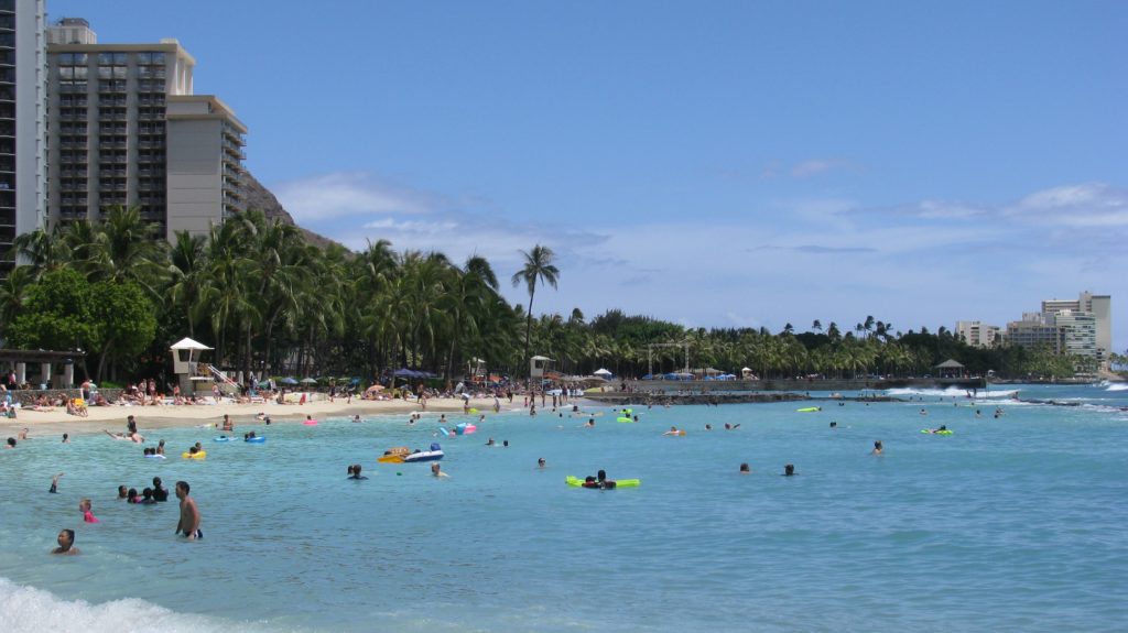
Hawaii Waikiki Beach
– I hope one day we can take Fu to Waikiki. Beach is surely the heaven for kids!
Hawaii Waikiki beachHawaii Waikiki beach
Places visited: Waikiki Beach, Pearl Harbor, the Island of Hawaii (Big Island)
– I am so glad that we went to the Big Island. That’s the best part of this trip 🙂
Restaurant: Marukame Udon (丸亀製麺)
– We went there three times. Every time there was a long line. Luckily the line moves fast, as the service there is fast. Basically you pick the type of soup (pre-made) for the udon noodle. They have tasty tempura too!
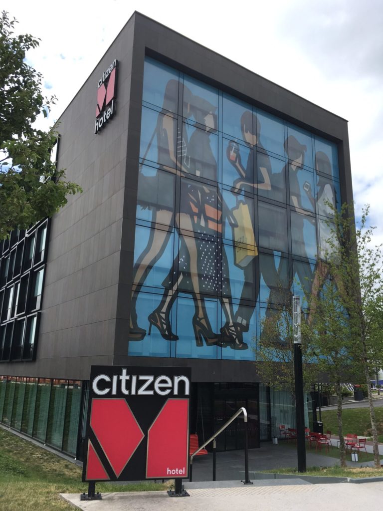
When we traveled from France to Finland, we stayed at the CitizenM hotel at Paris Charles de Gaulle Airport. The review of this hotel is exceptionally good, so I was a bit curious. Now I am convinced that this hotel totally deserves the high rating.
First of all, as a four-star hotel at the airport, its price is very modest. When I booked through Hotel.com about two months in advance, it was only a little more than US $100 (with a 12% off coupon though). Paying just 20~30 dollars more to stay right at the airport – why not? The hotel is located next to Hilton, close to Terminal 3. RER station is close-by. An airport train, TGVVAL, links all the three terminals.
CitizenM Paris CDG outsideCitizenM Paris CDG decorations
Secondly, the hotel is very modern and high-Tech. I found the painting on the outside wall very attractive. The inside decoration is also stylish – every touch is full of design. The words on the walls are interesting. I believe that every single piece of decoration is picked/collected carefully. People, including me, cannot help taking photos. The checkin and checkout are done at a round table with computers. Not sure about the checkin, but the checkout is self-service. You just put the card key on a reader, and then check out on the computer. It takes a few seconds. Every room is equipped with an iPad mini, which can be used to control almost everything in the room: light, shades, TV, etc.
CitizenM Paris CDG checkin
Thirdly, the staffs are nice. Since we traveled with a baby, the staff assigned us an accessible (larger) room, and offered a baby cradle. At the bar & restaurant, the bartender gave us a free beer 🙂 BTW, the food is good, and the price is ok – €24. Breakfast is about €18, with good selections of high quality.
Lastly, the room is extremely clean and quiet. The king bed and pillows are very comfortable. Wifi is stable and fast. Additional freebies include two bottles of water and MOVIES! Old movies and relatively new movies. I watched Passengers.
If I will stay at CDG again, I think I will go for CitizenM again. I heard it’s a chain hotel as well, so I will also look for it whenever I need a hotel.
Thanks to our failure in the lottery for the Wave, we had plenty of time in Zion National Park. Being different from other national parks in our Grand Circle trip, Zion has more plants, and seems more family friendly. Zion is only 40 minutes away from Kanab. Private cars are asked to park in the big parking lot close to the visitor center. Shutter buses are running every 10-20 minutes, depending on the season and time.
Zion National Park checkerboard mesa
There are numerous hiking trails in Zion. The two most famous and difficult ones are called The Narrows and Angel’s Landing. We did both!
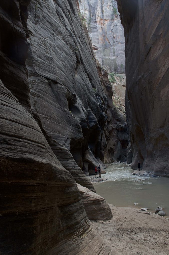
The Narrows
The trail is actually a section of the Virgin river running in the canyon. It is thus very important to check the weather and the flood potential. There are special preparations needed to be done as well. Keep in mind that the water may be cold! Even in early September when the sun is out and people are wearing shorts, the water is cold. This is because the river runs in the narrow canyon, and does not get much sunshine. Also, prepare “special” shoes because they will get wet for sure. The other thing may be useful is a stick, as walking in the river is difficult – you cannot see how deep the water is or what you are going to step on. We didn’t have sticks, so we were quite slow.
Two ways to hike The Narrows. One can either hike top-down or bottom-up. Top-down is an overnight hike, and requires permits. Bottom-up is easier, and requires no permits. Therefore most people, including us, choose the bottom-up hike. We took the shutter to Temple of Sinawava. After hiking the 1 mile riverside trail, we reached the starting point of The Narrows. I could see that people were excited to hike this special and unique trail! The first step into the water was really cold. After a while, I kinda got used to it. Walking in the river was more difficult than I thought, but it’s a lot of fun! My mom and I sometimes had to hold hand to stabilize each other. We reached the starting point of Wall Street, and then decided to return. In total, we hiked about 5 hours.
Zion National Park the narrows
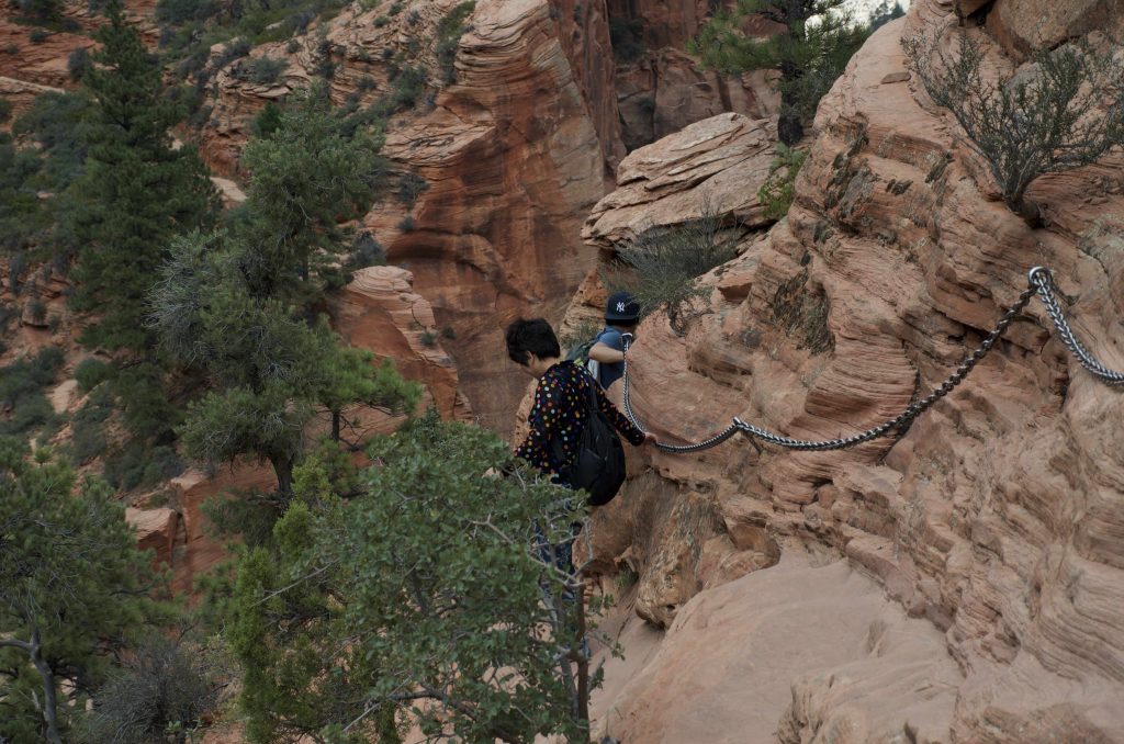
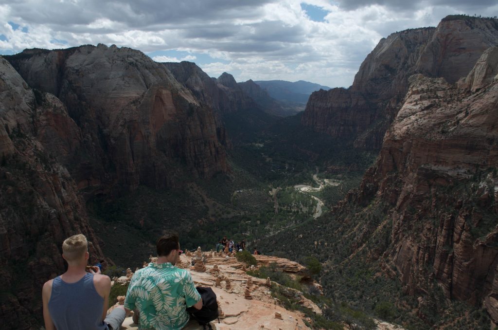
Angel’s landing
This is also a unique trail. The first half of the trail is paved road. However, the rest is rocks. There is a thick chain along the trail, so I don’t find it very dangerous. In fact, I liked it a lot! :). It reminded me the Yellow Mountain in China! The trail to one of the highest peaks, Tiandu Peak, is a bit similar. But it’s a lot more steeper on Tiandu Peak! (I recently revisited Yellow Mountain, and I will write about it. D had already finished his blog about Yellow Mountain.) The end of Angel’s landing is the top of the mountain. Many people were sitting there and enjoying the view. We didn’t stay long, because we had to drive to Bryce Canyon National Park.
Zion National Park angel landing chainZion National Park angel landing top
I am sure everybody can find some trails that they enjoy in Zion. I just feel lucky that we could do the two most unique ones!
One more thing about Zion. There are a lot of restaurant in Springdale. We tried one Thai restaurant (Thai Sapa), and the food we had there were surprisingly good!
Monument Valley kinda represents The West, as one can see in some movies about Westerns.It’s the second major stop, following Arches National Park, in our Grand Circle trip.Driving from Moab to Monument Valley Navajo Tribal Park takes almost 3 hours.We were hoping to catch the sunset!So we kept driving, except for a brief break at Mexican Hat.The weather was actually not promising.When we got closer to Monument Valley, we were caught in a storm.My plan of taking a photo of the straight road going towards those iconic sandstone buttes vanished!
When we arrived at the park, the storm has just passed.After paying the entrance fee ($20), we went ahead to the hotel – The View Hotel – the only hotel inside of the park.It’s the most expensive hotel we booked in our entire Grand Circle trip, almost $300 (on top of that, we also paid for the breakfast).Obviously we had high expectations for it.The style and color of the building match the surrounding very well.The hotel is almost like part of the park itself.The terrace is big, providing good views of the valley.The room is a typical American standard room.Not a bad size!The best part – also the most expensive part – is the private balcony!We could see the whole valley without going out of the room.Plus, the balcony faces east, which means sunrise can be seen directly from the room as well!To be honest, I have never been to a balcony that gives such extraordinary view…The whole valley was there for me to enjoy, in peace.
Sunset was not possible that day.But the air felt fresh after the storm.The temperature was very pleasant!And the valley looked more peaceful.I couldn’t help to admire those sandstone buttes, which have been standing there for who knows how many centuries.We didn’t go to the restaurant for dinner.Somehow we had a crave for instant noodles 🙂
The sky got darker and darker.We saw a few cars (lights) were driving in the valley.Were they local Navajo residents?
The second day, I got up early, and went out to the terrace with my camera (+ tripod).Yes, sunrise again!Why not?No need to drive, no need to hike – it’s probably the easiest sunrise (although people often miss the easiest things).I took many photos, with different settings.D and my mom didn’t come out.They saw sunrise on the balcony – a slightly different angle but equally good.I had to come out because I wanted a bigger view.It was a bit cloudy!But not too bad.The sun rose behind the center butte.
As mentioned earlier, we bought tickets for the breakfast buffet.The restaurant has big windows so people can enjoy the view of the valley while enjoying their meals.However the buffet was normal… not many choices.I kinda missed the breakfast in Best Western.
After the breakfast, we checked out.But we didn’t leave!Instead, we went for hiking.The only hiking trail in the park is called Wildcat, starting from the hotel.We spent some time looking for the start point of the trail.It was not as straightforward as we thought.Anyways, we found it!We hiked around one of the sandstone buttes.The closeup view was a totally different experience!We had to look up the sandstone butte –it’s so tall.Also, we got to get close to the local plants and animals.The temperature raised quickly as the day proceeded towards noon.We took many water breaks, and enjoyed the company of a dog (may belong to somebody).
Then we went for the 17 miles scenic drive. The road condition was much better than we thought. A 4WD was not necessary. Since hiking is not allowed without a guide, we basically stayed on the main road, and finished the loop quickly. I am surprised that I don’t have much to say about the drive… but it’s definitely worthing going!
With all the good memories of Monument Valley, we hit the road towards Page, Arizona.
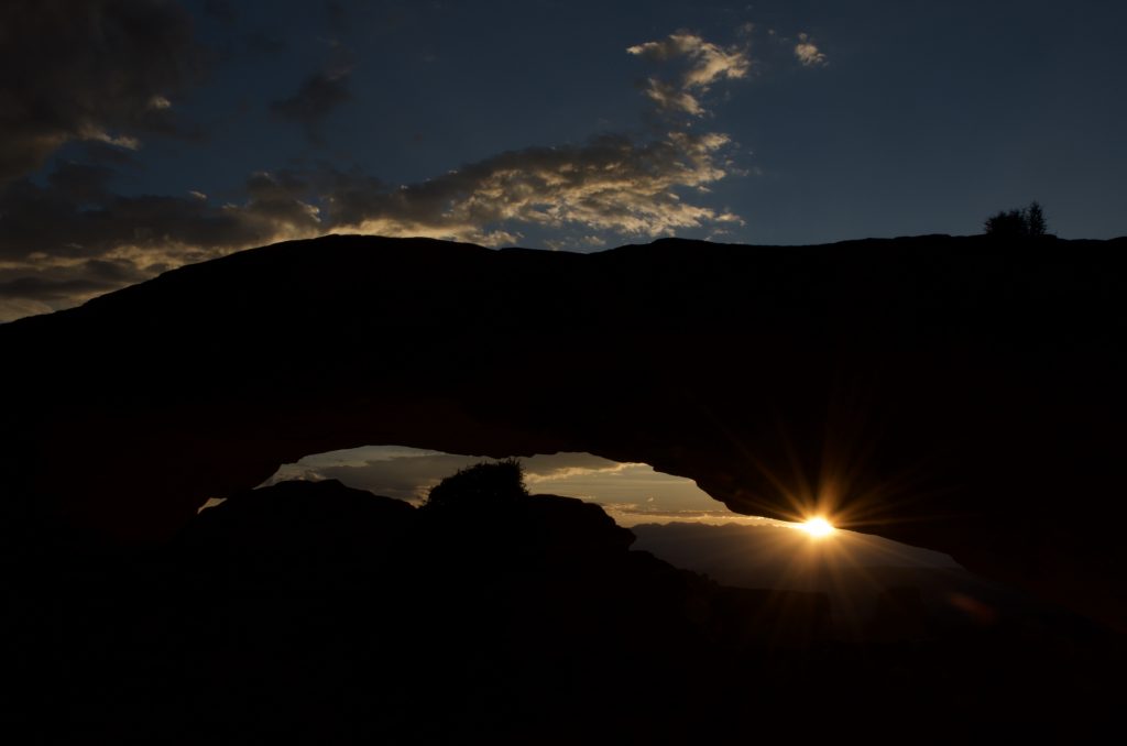
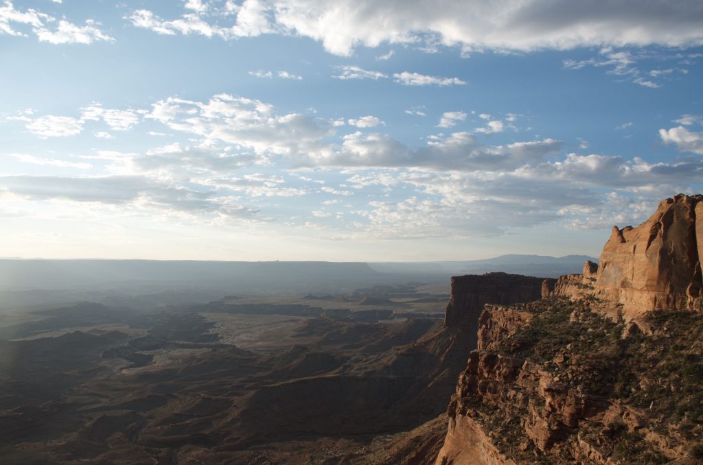
It’s the second day of our Grand Circle trip, and we planned to see sunrise at Mesa Arch.Since my mom got a little injury in Arches National Park the previous day, she didn’t join us for the sunrise.We also thought it’s better for her to rest more so that she would have energy later.However, it’s really a pity that she missed the best sunrise in the whole trip!
The driving from Moab to Mesa Arch, which is in Canyonlands National Park, was about 45min.In order to get a good spot for photography, we got up and hit the road very early (4:30am, 2h before the sunrise).I kinda remember that I was in the driver’s seat, so that D (my husband) could rest.After all, I am the one who is crazy about sunrise and sunset!It was still dark when we arrived at the trailhead parking area.But don’t worry – we had headlights!So prepared!The trail was said to be a 0.7 mile loop, so it should be only ~600m to the Mesa Arch.However, it took us a while to figure out which way to go, because the trail was not that obvious (remember? It’s dark).
We were among the earliest at Mesa Arch!I tested a few spots with my camera, and finally settled down.More and more people came.My spot was probably good, because several tripods were set up besides me.We were all quietly waiting for the moment.On the other hand, D was walking around – climbing up and down.
Waiting to see sunrise
The east started to show some red.After a while, the first sunshine came out and lighted up the quiet canyonlands.
Sunrise at Mesa Arch
We were still waiting.The moment has not come yet!People’s eyes were all on Mesa Arch.Slowly, the bottom part of the arch started to turn to a burning orange-red color!This magic didn’t last long, as the sun was rising.
Burning Mesa Arch
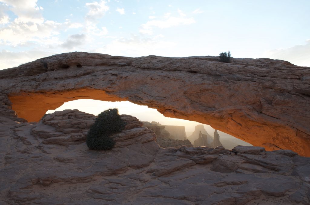
After the color faded on Mesa Arch, it’s officially post-sunrise.The sky was already bright.We realized that Mesa Arch was right on the cliff edge.Overlooking the vast canyonlands was also an unforgettable experience to us.Unfortunately, not a good time for photos (against the sun).
Overlooking the canyonlands
On the way back to hotel, we were quite excited.Plus, the breakfast in the hotel (Best Western Plus Canyonlands) was great!
We arrived a t Moab in the early afternoon. After checking into the hotel (Best Western Plus Canyonlands Inn), we did grocery shopping (City Market) to prepare for our Grand Circle trip: water and snacks. Our original plan was to leave for Arches around five o’clock. But we arrived one hour early, and didn’t want to wait in the hotel (which turned out to be a bad decision).
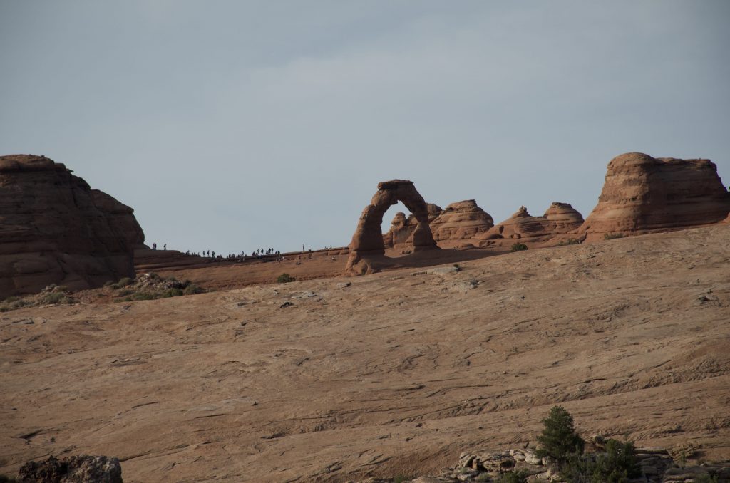
Arches National Park is only 8 minutes from Moab. We got a national park annual pass at the gate, for $80. After quickly going through the visitor center (we failed to get the ranger-guided tour to the Fiery Furnace), we headed towards the trailhead of Delicate Arch. The goal was to see the sunset and the moonrise (full moon) there.
After about half an hour, we found the trailhead (Wolfe Ranch parking area). The trail is 1.5 mile one-way, and climbs up ~150m. The thing was it’s really really hot! The temperature in the forecast was 39 or 40 degree C, and it should be much higher on the rock. After hiking about 20 minutes, my mom suddenly fell towards the front when she was drinking, and I couldn’t catch her! She hit the ground (rock), but was still trying to hold the water bottle. Fortunately it’s a relatively flat area, otherwise I cannot imagine! Her nose was scratched by the sunglasses. Her knees were bleeding a little. My husband (boyfriend at the time) and I helped her to move to the shade, and washed her wound. We asked her to drink water and just rest. She probably passed out for a second because of the heat! Plus, we didn’t take any break during the 20min hike… Not to say that we had an early and long flight, and some driving! We really should have rested more in the hotel.
Delicate Arch and people waiting to see sunset
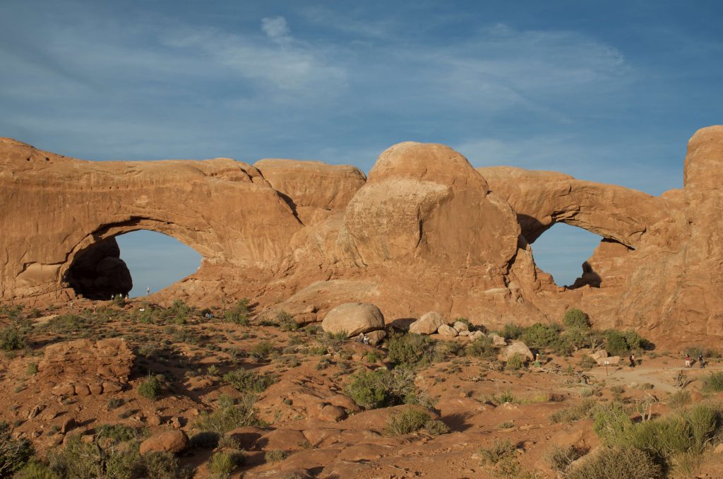
We gave up Delicate Arch, but could see it from the Lower Delicate Arch Viewpoint. Then, we went to the Windows Section, because arches there require little hiking. When we were leaving Arches, we saw the moonrise.
Arches National Park Spectacles Arch
The second day, we came back to Arches again, after seeing the sunrise at Mesa Arch in Canyonlands National Park (I have to write a separate post for Mesa Arch because it’s too good) 🙂
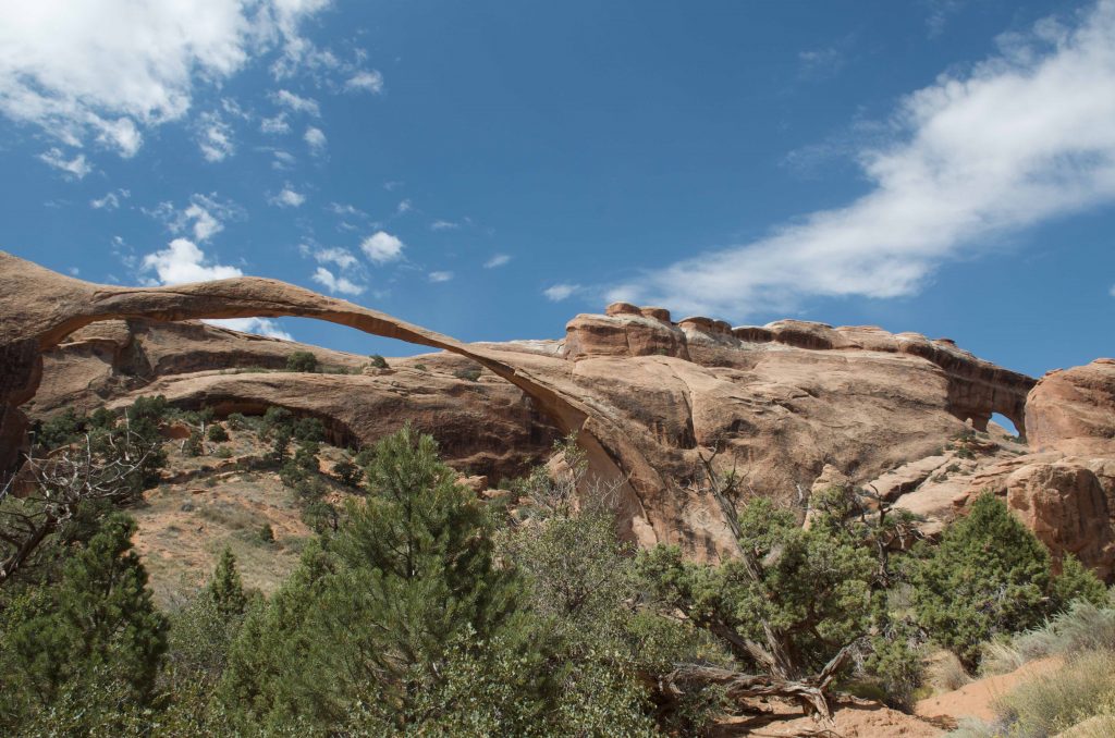
My mom seemed recovered from the first day, so we decided to try a little bit hiking again! This time Devils Garden. It was also a sunny day. The driving from the visitor center to Devils Garden was half an hour. The trailhead is a big parking lot, and has restrooms. The trail is quite easy. And more importantly, we were more prepared, both physically and mentally! The total distance covering all the trails is 7.2 miles, but we didn’t set a goal. We hiked at a slow pace, and took many water breaks (even when we didn’t feel the need to take a break).
Landscape Arch, Arches National Park
So it was a leisurely hike. We saw Landscape Arch! This arch is very different from the others. So long, and so thin. Interestingly, there were many small rocks below it – looked like debris of collapses. It’s said that Landscape Arch may break/disappear one day?
We didn’t have energy to hike to the Double O Arch, so just took the same way back. We were very pleased with the 2h hiking 🙂
After a quick bite in a cafe in Moab, we started driving towards Monument Valley…
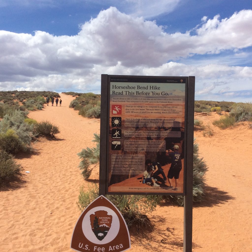
After the Antelope Canyon tour, we went to see the Horseshoe Bend, which was only a short drive from Page, Arizona. To get to the rim of canyon to see the bending Colorado River, one must hike the ~0.7 mile trail. Yes it’s just a short trail, but imagine hiking in a hot and dry environment (> 37 degree C), under the early afternoon sun, and on a sandy surface. We had to take a water break every 150-200 meters.
Horseshoe bend trail
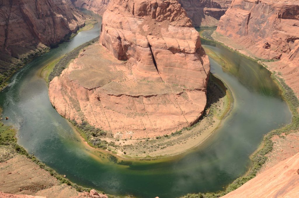
When we reached the rim of canyon, the extraordinary view made us forget about everything else. The jade-color Colorado River plus the reddish sandstone – perfect! And the horseshoe-like turn (wide sweep) made by the river is simply amazing! This place reminds me the Grand Canyon, but isn’t the color of Colorado River red there? I would have to check my Grand Canyon photos later.
Colorado River makes a wide sweep around a sandstoneThe beautiful Colorado River
Photos! I tried many spots to take photos. Luckily I was not afraid of height! The lens I had was 18-140mm, so the frame could barely cover the whole ring of Colorado River. However, it would be much better to include more of the canyon and the blue sky as well. I needed a wide-angle lens, didn’t I?
I also wish I could see sunrise here. That should make a great photo! But I figured it might be too tough for my husband and my mom if I requested sunrise/sunset stuffs everyday… At a middle point of our Grand Circle trip, we were already very tired.
Every winter, people from all over the France or even the world come to Grenoble for skiing.There are world-famous big ski resorts, and also small local favorites.Although I have a good reason (unfortunately) not to ski, it would be a shame spending a whole winter in Grenoble without seeing the snow mountains.Not to say that I do love snow skiing.
Here’s the deal.My father-in-law flew all the way from Japan to France to ski in Alpes, so we picked a big and well-known ski resort – Les Deux Alpes.Our concern was whether the high altitude would affect my pregnancy (7/8th month).After all, we would spend three days above 1800m, and I would very much like to go to the top of the mountain, which is 3600m.Found some articles online saying that above 2000m was not recommended… So we thought that 1800m might be fine!Actually, in China, we visited Huanglong when I was three months pregnant.Huanglong is above 3200m, and on the way to Huanglong the highest point is above 4000m.Our baby seemed OK for the high altitude!
So we started to plan our trip.First of all, we booked the hotel – Turan, because it has direct access to the slopes.Then, we purchased the ski pass for the first day online, and requested the cards to be mailed to our home.After receiving the cards in the mail, we purchased the ski pass for the following two days using the card numbers (for insurance).Somehow without the card numbers, it’s only possible to get insurance for the first day.That’s why we purchased our three days’ ski pass separately.If you do not want the insurance, then you can just purchase the ski pass (for as many days as you want), and pick up the card in the resort.The last thing we booked was the bus tickets – from Transaltitude.€ 15 per person, one-way.The bus leaves from the Gare of Grenoble, and it takes about 1h 40m to reach Les 2 Alpes Ski Resort.
We were probably the last ones to board the bus, and it was quite full!Maybe becauseit’s the peak season – February, there were some traffic going into the mountains.We got off the bus at the first stop – Point Info, which we thought was the closest to our hotel.There’s an information center right there.We got maps, and asked for directions to the hotel.Without any difficulty, we checked into Hotel Turan.The girl at the front desk was very helpful.She showed us the ski dry room and where the lift was.She also gave us coupons for the ski rental and a close-by Italian restaurant (we ate there every day)!Talking about ski rentals, we probably should have made reservations at home, but we didn’t realize until the day before our trip, and it was already too late!You can’t reserve rentals for the next day!However, thanks to the coupon from the hotel, I guess we still got a pretty good deal.So don’t forget to ask the hotel for coupons 😉
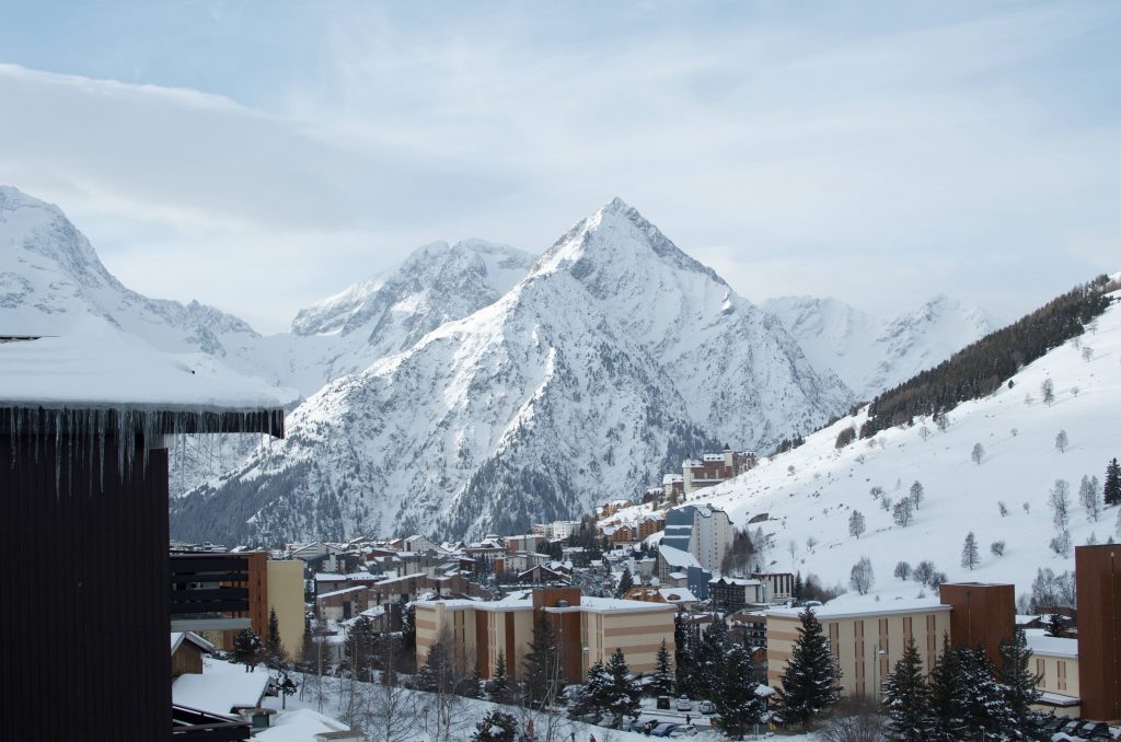
After lunch (already 3pm), my husband and his father went to skiing.I, of course, stayed in the room.The size of the room was OK.There were two single beds and a bunk bed.The room was simple, but adequate.
The view from balcony, Hotel Turan
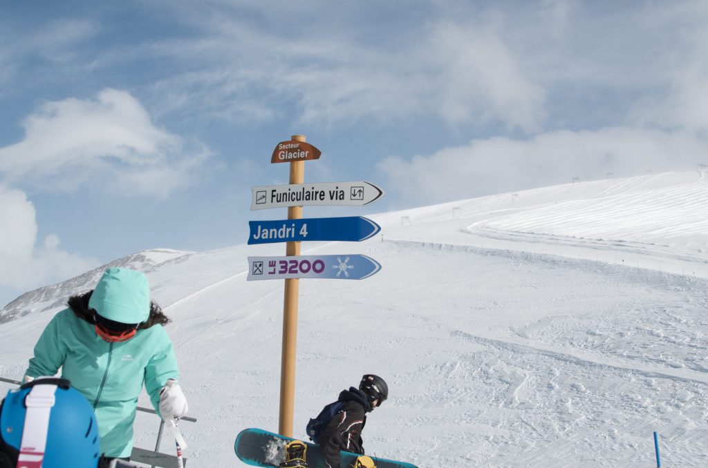
The second day, I also went out after they went for skiing.I took the free shuttle to the center of the village (@1650m), because we planned to meet there to take the lift Jundri Express #1 to 2600m.That lift is for both skiers and walkers.I didn’t feel bad in the lift, but I was still a little bit worried.Then, we took Jundri Express #2 to 3200m!Although it’s almost the highest point, the slopes were actually easy.That’s why Les 2 Alpes is good for skiers at all levels, even I could come up to the top and ski (if I were not pregnant)!In USA, however, I usually couldn’t go all the way up to the top, otherwise I might get stuck there.
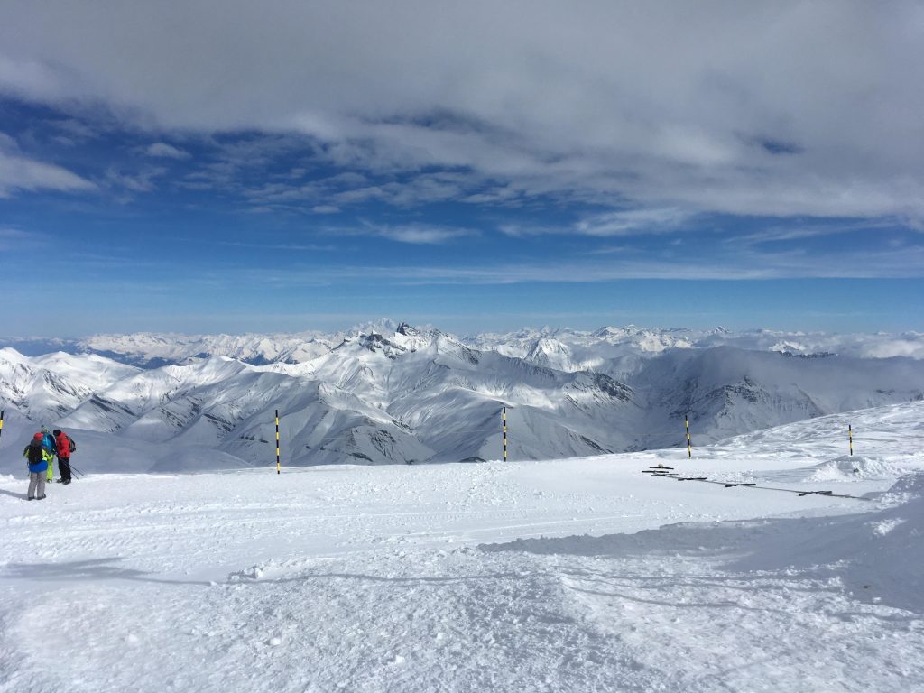
The view at 3200m was wonderful!Since I didn’t feel bad at this altitude, I decided to try a little bit more, 3400m.There’s an overlook up there.To get to 3400m, we had to take a cable car to go down a little to reach the other cable car, which goes up to 3400m through a tunnel.If you are a skier, then you have other lifts to go to 3400m, but I don’t have other choice.Maybe because it’s not used often, that first cable car was not functioning well – we got stuck!With operator’s help, it still took a few minutes for us to get to the second cable car.The second one is much bigger, and is used routinely – many other passengers.When we get to 3400m, one operator told me that it’s windy outside so it’s too dangerous for pedestrians.I had to go back to 3200m, immediately.OK then.We took the same way back to 3200m.Yes it’s windy!I took the Jundri Express #2 back to 2600m.My husband and his father skied down to meet me.I went back to the hotel after lunch at 2600m.For me, that’s all I did in this ski trip, except for staying at the hotel and sightseeing in the village. The photo below was taken by my husband, at 3600m. Plus, you can find his post here, if you understand Japanese 🙂
Jundai express 1 & 2 take you to 3200mThe view at 3600m, Les Deux Alpes
The village has so much to offer!Cinema, bowling, post office, library, museum, pool, restaurants, shopping, … And the shuttle service is so convenient.If I had one week here, I would be able to explore more.I heard there were short tours to other close-by villages.So, besides skiing, there are still a lot to do here in Les 2 Alpes!And thanks to the high altitude, skiing is even possible in the summer (above 3200m)!
Now, I want to compare Les 2 Alpes with some ski resorts in USA.I lived on the east coast, so you know immediately that there are no comparable ski resort to Les 2 Alpes! The skiable area is much much smaller, the slopes are much much shorter,… ok no way to compare with the vast Alpes.Let me just introduce some ski resorts in USA – in Virginia and West Virginia.The best ski resort we have been to is Snowshoe Mountain ski resort, which is said to be the largest in the mid-Atlantic.We liked it!The village is built on the top of the mountain.We watched sunrise from our room!Next level ski resorts are Beach Mountain, Sugar Mountain, and Wintergreen.The smallest we have been to is Cataloochee.Often, they have to use snow-making machines to maintain the slopes.Although the ski resorts in USA are much smaller, the price is higher (~30%)!Especially in the holidays and weekends!Very crowed as well.Maybe Colorado is a different story!When we were in Snowshoe, somebody (a lift sharer) told us about The West with an expression of excitement – looked like Snowshoe was nothing to him (in contrast, we were already amazed by Snowshoe).Now after seeing the Alpes, I felt like I could understand that guy a bit…
Alpes is Alpes.I am glad my baby saw it as well.And, we will come back!
Lastly, just one comment about the pregnancy.Based on my experience, a few hours at high altitude seemed fine.But it’s just me!Anyway it should not be recommended.My husband was scared.Poor him.
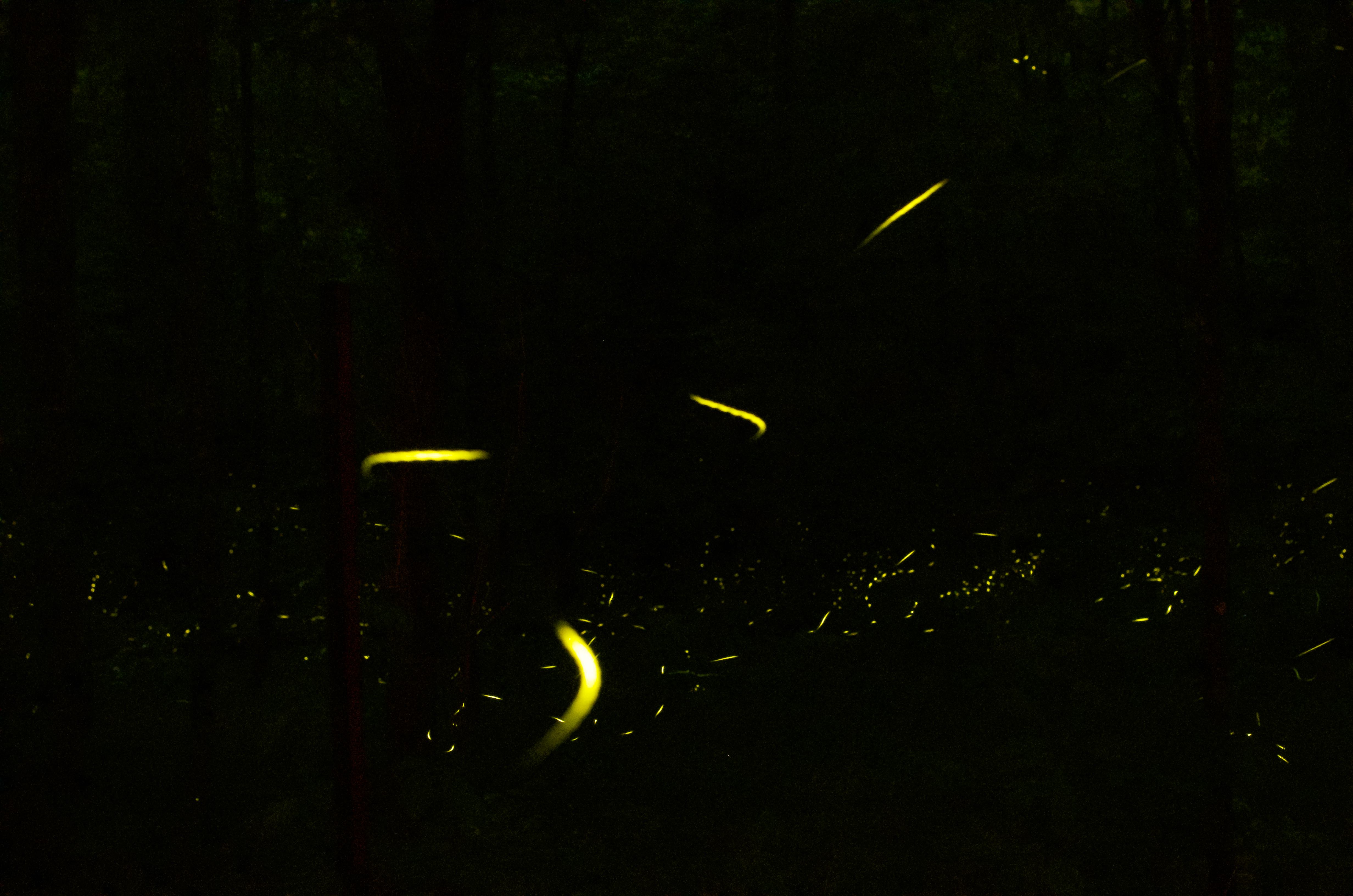
The warm wind reminds me that it’s almost the time to reserve tickets for a special light show in the Great Smoky Mountains National Park. This show is presented by small insects that all of you are familiar with – fireflies. I guess everybody has good memories of pointing out fireflies in the backyards in summer evernings. Those sudden light ups are like shooting stars… And if there are a lot of fireflies, they look like Christmas lights.
There is one special species of fireflies living in the smokies. They are called synchronized fireflies! As you can guess from the name, these fireflies flash together. Isn’t that amazing? How do they communicate to each other? Why do they synchronize? They are certainly not doing this show for us… I heard it’s for their mating, but I am not sure why the synchronization is important. There are information elsewhere, here I want to talk about my four years’ experience on watching their show – more specifically, how to get a ticket, what to prepare before going, how to get there, and what to expect to see.
So, the most important thing is to get a ticket! The mating season of the fireflies lasts about two weeks. Based on the weather, the National Park Service (NPS) will estimate and announce a 8/9 days window for the peak flashing (late May to mid June) of the synchronized fireflies. The announcement is usually made a few days before April 30th. Please check their website for the dates! Before 2016, part of the tickets (“Advanced Tickets) were distributed online at 10am EST on April 30th. And those tickets were gone within three minutes! The rest of the tickets were called something like “day before tickets” (you get it today and go tomorrow), and were available through phone calls on a first-come-first-serve basis. I have had success with both methods. The key was to be prepared! No waste of one second. I could share some tips, but they have already changed the rules! Since 2016, all the tickets are distributed via a lottery system! Basically, they open the lottery in the end of April, and close it in two/three days. A week or so after the closing date, people will be notified of the lottery results. Last year, I was lucky! Since you can only choose two days in the application, my philosophy was to avoid the weekends so that the chance would be much higher. If you are unlucky, there is another way to get to see the show – camping at Elkmont Campground! From the campground, you can simply walk to the site to see the synchronized fireflies. Remember that those camp sites are also filled quickly. But don’t be too frustrated if you couldn’t get the date you want. Check back often in case there’s cancelation.
Now let’s come back to the “normal” tickets. I haven’t told you that the tickets are actually parking tickets! Most of the tickets are for standard cars, and up to six people are allowed for one car. There are a few tickets for busses, which can take more people. You need to drive to Sugarland Visitor Center. There will be officers doing traffic control and ticket admission. Only the cars with tickets are allowed to park at the visitor center. One car one ticket (the confirmation email that NPS sends out), and the ticket holder must be in the car. The officer will count people in the car, and give a trolley ticket to each person. After parking the car, you get into the line (there’ll be a line, a long line) for the trolley. You need the trolley ticket and 1$ to board the trolley. I think the trolley starts to take people to the Elkmont area from 7-ish. Except for campers, no private car can access the Elkmont area during the show days (the 8/9 days for the synchronized fireflies).
The trolleys will take you to the Elkmont area. From there, just follow the crowd. At the entrance, you will be given a handout introducing the synchronized fireflies. You can also get a piece of red cellophane and a rubber band to cover your flashlight/phone. This is very important, as the white light will disturb and confuse the fireflies! You are there to see the show, not to be part of it.
Since it’s early June, the sky does not get dark until 9pm. You will have plenty of time hanging around and looking for a good spot. You probably want to take a light and foldable chair with you 🙂 Not a bad idea to have a picnic there.
You sit down, and wonder what the show will be like… While the sky gets darker and darker, you see more and more white dots flashing (somehow yellow in photos). At the beginning, they are not synchronized. But as the show proceeds to peak time, you will see a wave of flashing. I mean, not all the fireflies are synchronized to one rhythm. It’s more like: this region of fireflies synchronized to this rhythm, and that region of fireflies synchronized to that rhythm. Another thing is that those fireflies have different levels of performance in the 8/9 days window. I have seen the light show six times (once or twice a year), and I can tell there’s clearly a difference (sometimes a big difference)! Nevertheless, it’s always an incredible experience.
Being immersed in flashings, you will forget about the time! And soon you realize that people are leaving. When you get back to the entrance (where the trolley drops you), there’s a long long line. We have once waited for more than an hour. So, might be a good idea to slowly move towards the entrance between 10 and 10:30.
Lastly, I just want to say that be nice to the fireflies, and be nice to people. Don’t do things that you don’t want other people do to you. Pay attention to your flashlight and phone!
Bryce Canyon National Park was the last stop in our Grand Circle trip. Since we spent three days around Kanab (for The Wave lottery), and we needed to drive 6 hours to Grand Junction, we didn’t have much time in Bryce – only one night and one morning!
When we arrived at Bryce, it’s almost the sunset time. I think we went to the sunrise point for the sunset (counterintuitive). Unfortunately, it was a bit cloudy that day. Thinking about our whole Grand Circle trip, we seemed to have better luck for sunrise than sunset. Anyways, we were still impressed by the hoodoos!
Shortly after the sunset, we went to our hotel Best Western Plus Ruby’s Inn (right outside of the park). The hotel is like a big resort. The lobby is Mountain style, and has a lot to offer. Still, the best part is its easy access to the park!
For the first time in our Grand Circle trip, we went out to do star gazing. And truly, Bryce is the best place that I have been for stars. The clouds were all gone, and the starry night sky is breathtaking! I have never seen so many stars before! I felt my body was immersed in stars. I felt lost… it seemed more difficult to tell constellations with so many stars. To me, who has loved star gazing for two decades, that place was like heaven!
I took out my camera, and tried a few long exposures. I have always wanted to shoot the Milky Way and the star trails! It’s cold and windy up there, but I was excited. If I was more crazy, I should have gone down the canyon and took the shots on one of those hiking trails so that I could have hoodoos in the foreground… Next time!
Since we planned to see sunrise, and we would have long driving the following day, we went back to the hotel to catch some sleep. Then, the second day we went into Bryce for the third time! I forgot where exactly we went to see the sunrise… probably the Inspiration Point? Again, it was a bit cloudy… but better than the previous day. Where did the clouds come from? It was clear in the night! We were among the early ones, and could find a good place to see the amphitheater. Just like those hoodoos – we were waiting quietly. It also felt like we were waiting for a show. It’s a amphitheater, isn’t it? When the light shined upon the hoodoos, they became alive. So, at one moment, this part of the amphitheater was playing; and at another moment, the other part of the amphitheater became active. With sunlight, the color of stones are so glorious – burning orange. In my eyes, that color felt young and full of energy!
We then drove back to the sunset point, and did about one hour’s hiking on the Navajo Loop Trail. It was a nice morning hike in the sunshine and cool air – very different from other hikes we did earlier. Getting close to the hoodoos also allowed us to admire those creatures in another angle. We were very pleased to finish our Grand Circle trip with such a relaxing hike.